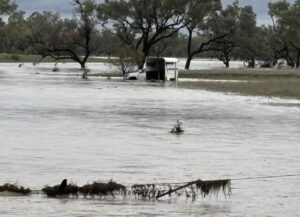
Western Queensland is now facing severe flooding, with some areas reaching depths higher than the record-breaking 1974 floods.
As of Tuesday night, reports indicated that an area twice the size of Victoria was underwater, much of it farmland, leaving entire communities stranded.
The impact of these floods will be devastating, with massive losses of livestock and infrastructure, including dams, fencing, roads, tanks, troughs, yards, and machinery. Any surviving stock will require feed, which will need to be airlifted in. Beyond those directly affected, the disaster will have significant ripple effects on surrounding towns and districts, particularly with supply chain disruptions.
Once again, Neighbourhood Centres have been essential in supporting their communities, leveraging their local knowledge and trusted relationships. They are working closely with local councils and organisations to coordinate relief efforts, including household support and fodder drops for farmers. Centres are also conducting welfare checks on residents in their townships and surrounds to ensure their safety and wellbeing.
- Charleville and District Community Support Association Inc., through their Family Support Service and Supported Accommodation Assistance Program, are providing support to evacuees from Thargomindah and are expecting more.
- Blackall Neighbourhood Centre is the central drop off point for community donations to outlying communities including Adavale, Jundah and Windorah, as well as the base for fodder collection and dispatch, with a Blackhawk helicopter providing fodder relief to Windorah, Jundah & Stonehenge. They have also conducted welfare-checks via phone to hundreds of properties.
- Paroo Community Support Service are supporting Paroo Shire Council operations, who are conducting food and fodder drops, assisting with isolated townships of Yowah and Wyandra. Residents are being evacuated from Eulo.
- Winton Neighbourhood Centre are calling all properties in the region to conduct welfare checks and the impact of flooding in surrounding rural locations, as part of their operations with Winton Shire Council.
- Boulia Community Support Service are currently supporting the town which is presently cut off, distributing short term emergency food supply and monitoring transport routes from Townsville.
- Mount Isa Neighbourhood Centre are also monitoring transport routes and the impacts of food supply to the town, as many are cut off due to flooding.
[Pictured: Flooding west of Tambo, courtesy of Blackall-Tambo Regional Council]
Written by: Ally Kodet-Moran
Published: April 2025